What is safeguarding?
The Purpose and Legislation of Aerodrome Safeguarding
Aerodrome Safeguarding ensures the safety of aircraft manoeuvring on the ground, taking off, landing or flying in the vicinity of the aerodrome.
Aerodrome safeguarding is a legal requirement under ICAO (International Civil Aviation Organisation) and the UK CAA (Civil Aviation Authority). The processes undertaken to safeguard aerodromes are regularly audited by the UK CAA (Civil Aviation Authority).
Certain aerodromes are protected in law by UK Government (Department for Transport). These certificated and licensed aerodromes are currently listed in ODPM/DfT Circular 01/2003 ‘Safeguarding of Aerodromes, Technical Sites & Military Explosives Storage Areas Direction’. This measure ensures that aerodrome operators are statutory consultees in the planning process and can check that the safe operation and development of their aerodromes are not impacted by external developments. The circular for England & Wales can be found on the Government website and for Scotland you will find it on the Scottish Government website.
Consultations
The Government directs Local Planning Authorities (LPAs) to consult with officially safeguarded aerodromes. The aerodromes lodge safeguarding maps with the LPAs and whenever a development of a specified height is proposed within the colour coded area (distances may vary between aerodromes) a consultation is required. There will also be a 13km wildlife circle depicted on a safeguarding map, in which the aerodrome will wish to be consulted on any developments that have the potential to attract wildlife; birds will be the main concern in the UK.
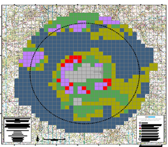
Some aerodromes will also have a renewable energy safeguarding map within which the LPA will need to consult the aerodrome about wind turbines. These typically extend out to 30km but can vary between aerodromes.
The consultation process enables an aerodrome to comment on any development that may affect its existing or future operation. Refer to the above-mentioned circulars and CAP 738 ‘Safeguarding of Aerodromes’ for further information.
Non officially safeguarded aerodromes do not have the same protection so are encouraged to take steps to protect their aerodromes from the possibility of adverse development by establishing an agreed consultation procedure between themselves and the LPAs. For further advice refer to CAST GA1: ‘Safeguarding Guidance to General Aviation Aerodrome Managers & Operators’ for further information.
Prior to formal consultations on planning applications from the LPA, aerodromes also welcome pre-application enquires from LPAs, developers and other organisations and also consultations in relation to planning policy. Note that some aerodromes will make a charge for giving pre-application advice.
If a proposed development raises aerodrome safeguarding concerns, an aerodrome may need to engage with the developer to ask for further information or to request design amendments to a scheme. Aerodromes are always keen to work with LPAs, developers and others to find solutions suitable to all parties where possible. The aerodrome may ask that conditions be added to a planning consent to enable it to go ahead without presenting a flight safety hazard.
Aerodrome Safeguarding Considerations
When assessing a development for any potential impacts on aviation safety there are many factors that need to be considered as follows (this list is not exhaustive):
The OLS surround the airport and typically extend out to 15km from the Aerodrome Reference Point (ARP) though this can vary between aerodromes. They are designed to protect aircraft from obstacles when manoeuvring on the ground, taking off, landing or flying in the vicinity of the aerodrome. It is important that these surfaces are not infringed by new development.
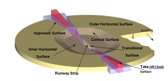
The OLS represent the lower limit of the blocks of protected airspace around an aerodrome. They form a set of 3 dimensional surfaces which extend upwards and outwards from the runways encompassing the critical airspace utilised by air traffic. As follows:
- ‘The Take Off Climb Surface & The Approach Surface’ are sloping surfaces that rise from beyond the end of the runway, proposed developments must not infringe these surfaces.
- ‘The Transitional Surface’ is a sloping surface rising from the side of the runway strip, proposed developments must not infringe this surface.
- ‘The Inner Horizontal Surface’ this is a flat surface and joins the Transitional and Conical Surfaces.
- ‘The Conical Surface’ this is a sloping surface rising upwards from the periphery of the Inner Horizontal Surface to the inner edge of the Outer Horizontal Surface.
- ‘Outer Horizontal Surface’ this is a flat surface that reaches out from the periphery of the Conical Surface, typically this is out to 15km, however it can very between aerodromes.
Refer to chapter 5 of CAP 738: Safeguarding of Aerodromes for further details of the OLS.
Note: There are other restrictive surfaces as well as the OLS for example those used for CNS (Communication, Navigation & Surveillance) equipment and Instrument Flight Procedures (IFPs) which on occasion can have lower height restrictions. These are described below.
Proposed buildings and structures can affect equipment used by both the aerodrome and aircraft. The equipment is collectively referred to as Communication, Navigation and Surveillance (CNS) and is essentially the ground infrastructure used by both Air Traffic Control (ATC) and aircraft. Aircraft can be those approaching/departing an aerodrome as well as those further away and in the cruise. This equipment is mostly a form of radio equipment. As such, potential issues can include:
- Signal reflection
- Refraction or false plots on radar
- Interference/clutter and false plots on radar displays
Any large areas of metallic/reflective materials must be avoided as they can cause signal reflections and glint and glare distractions to aircrew and ATC.
Telecoms installations can affect CNS equipment, especially 5G whose spectrum can have an effect on S band radars. Therefore, it is essential that early consultation with the aerodrome takes place. For further reading refer to the following:
Ofcom frequency and technical information
5G has the potential to affect aircraft radio altimeters, this is currently being monitored by the Civil Aviation Authority (CAA) and they have issued a safety notice SN-2021/017: Potential Interference Risk to Radio Altimeters from 5G Mobile Technology
Note: The protected surfaces for CNS equipment can be lower than the OLS height restrictions, so early assessment is important.
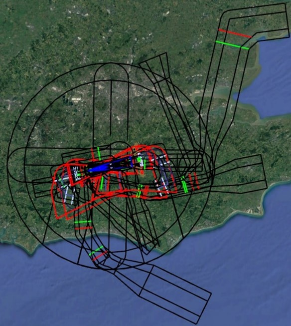
Instrument Flight Procedures are a series of predetermined manoeuvres, by reference to aircraft flight instruments coupled with ground based navigational aids or satellite navigation-based waypoints, with specified protection from obstacles.
An IFPs primary purpose is to provide clearance from obstacles and to allow safe aircraft operations to/from the runway to/from the airways network or the local airspace.
Note: IFPs extend further from the aerodrome than the Obstacle Limitation Surfaces (OLS) and the IFP protected surfaces or minima may be lower than the OLS in certain areas. This is dependent on the type of IFP.
If a development is likely to impact on an IFP(s) we will request that a full IFP assessment is carried out by the Approved Procedure Design Organisation (APDO). The cost of the assessment and analysis of the findings, will be borne by the developer.
At night and in periods of poor visibility during the day, pilots rely on a particular pattern of aeronautical ground lights, principally the approach and runway lights, to aid in aligning themselves with the runway to land at the correct point. Depending on their location several types of lighting have the potential to cause issues for example:
- Temporary lighting e.g., construction lighting, light shows, temporary installations
- Advertisements
- Lighting of buildings and other structures
- Street and car park lighting
- Flood lighting at sporting venues or similar
No lighting should be displayed which could distract pilots or confuse them by being mistaken for aeronautical ground lights. Further details about the design of road lighting in the vicinity of aerodromes can be found in British Standard BS 5489 1:2020 ‘Code of Practice for the Design of Road Lighting’.
When designing any lighting in the vicinity of an aerodrome, including temporary e.g., construction lighting, the following must be taken into consideration:
- Any aeronautical ground lighting is not obscured from the pilot’s view
- Any proposed lighting cannot be confused with aeronautical ground lighting, for example replicating the same patterns or colours
- Any proposed development must not include a high level of background lighting which could diminish the effectiveness of aeronautical lighting
- Any proposed lighting must not have the potential for glare or dazzle to pilots or Air Traffic Control (ATC)
- Any proposed lighting must not infringe the Obstacle Limitation Surfaces (OLS) for the aerodrome
The Air Navigation Order (ANO) under Part 8 ‘Aerodromes & Lighting’, Chapter 2 directs that:
| 225. A person must not in the United Kingdom direct or shine any light at any aircraft in flight to dazzle or distract the pilot of the aircraft’. |
Owners of lights must always follow any notice that may be issued under the ANO to dim or extinguish lights, pending resolution of any problems that arise when the lights are in use.
For further information refer to CAP 736: Operation of Directed Light, Fireworks, Toy Balloons and Sky Lanterns within UK Airspace
Wind turbines have the potential to adversely impact on primary radar returns because the rotating blades cause ‘clutter’ and false aircraft tracks on the radar operator’s screen. Secondary radar can also be disrupted as wind turbines can cause misplaced aircraft returns on the operator’s screen.
Tall wind turbines also have the potential to infringe the Obstacle Limitation Surfaces (OLS) and impact on Instrument Flight Procedures (IFPs). For further reading refer to CAP 764: CAA Policy and Guidelines on Wind Turbines.
Solar PV installations need to be carefully assessed because, depending on their location, orientation and overall size, they have the potential to deflect radar and can cause a glint and glare hazard. Aerodromes may request that a developer provides an aviation perspective solar hazard glint and glare assessment, to predict what the impact of the array will be. It is possible for solar installations and aerodromes to co-exist; in fact, some airports have their own installations.
If a solar installation is roof mounted, there is also the potential for it to infringe the Obstacle Limitation Surfaces (OLS) and to impact on Instrument Flight Procedures (IFPs) and Communication Navigation and Surveillance (CNS) equipment. Solar installations can also be attractive to birds for nesting, roosting and loafing, therefore the supporting structures may need to be bird proofed.
Aircraft are highly vulnerable to wildlife strike risk and species such as deer, badger and foxes can cause safety concerns, however birds are the most problematic species in the UK. It is estimated that damage to aircraft and flight delays resulting from wildlife strikes around the world cost hundreds of millions of pounds per year.
Bird strikes are one of the aerodromes top risks and they are required under ICAO & CAA regulations to ‘reduce the attractiveness of the area to birds/wildlife on and in the vicinity of the airport’. Aerodromes will have a robust wildlife hazard management regime with regular patrols by dedicated personnel on the airfield and some will also undertake regular monitoring out to a radius of 13km from the airport
Developments that have the potential to increase the bird strike risk are:
- Areas of water such as reservoirs, lakes, ponds and wetlands including Sustainable Urban Drainage Systems (SUDS)
- Sites being used for the handling, compaction, treatment and/or disposal of household and/or commercial wastes
- Nature reserves or bird sanctuaries
- Sewage disposal, treatment and outfalls
- Mineral extraction, quarrying and their restoration schemes
- Large landscaping schemes with a high percentage of berry/fruit bearing species that could attract flocking birds in large numbers
- Buildings with large areas of flat, shallow pitched and/or green roofs. There are now significant numbers of Gulls moving inland and nesting and roosting on these types of roofs. The potential is there for Gulls to transit the aerodrome and approach/take off paths when travelling between roosting and feeding/bathing sites. We may ask that a Bird Hazard Management Plan be entered into to ensure that Gulls do not become established on roofs.
- Large areas of ground re-profiling works as they can uncover worms and insects which could attract birds in large numbers
- Golf courses which may offer opportunities for waterfowl due to the creation of new waterbodies and the short grass provide potential feeding opportunities for grazing Feral Geese.
Not all the above may cause issues. It depends on the scale, design, proximity to the aerodrome and known bird sites. All developments are considered on a case-by-case basis.
Biodiversity enhancements and the need to not increase the bird strike risk to the aerodrome can co-exist if designed correctly.
Some examples of biodiversity enhancements that are unlikely to increase the bird strike risk to the aerodrome, subject to further details and site-specific analysis are:
- The creation of butterfly glades
- Green walls
- Bat boxes
- Bird boxes for smaller species such as wrens, sparrows, robins etc.
- The creation of Hibernacula
- Small ponds that will attract newts, dragon flies etc. which are designed correctly and mitigated to ensure that hazardous waterfowl, water birds and Gull species are not attracted.
For further reading refer to CAP 772: Wildlife Hazard Management at Aerodromes
Cranes and other construction equipment such as piling rigs, mobile lifting platforms etc. can affect the safe operation of the airport if their height infringes the Obstacle Limitation Surfaces (OLS) and they can become an obstacle. They can also affect Communication, Navigation & Surveillance (CNS) equipment and/or Instrument Flight Procedures (IFPs).
Anyone operating a crane, or any tall construction equipment is required to apply for a permit from the aerodrome if the equipment is:
- to be used within 6km of an aerodrome and its height exceeds 10m Above Ground Level (AGL) or that of surrounding structures or trees, if higher
or
- to be operated at or above a height of 100m AGL regardless of location or height of surrounding structures.
For further information with regard to the crane permit process refer to CAP 1096: Guidance to crane users on the crane notification process and obstacle lighting and marking
Metallic or reflective materials, for instance cladding and large areas of glass can cause radar reflections and/or glint and glare which can affect aircrew and Air Traffic Control (ATC).
Depending on the extent of the surface and the proximity of the development to the aerodrome a glint and glare study may be needed.
If a development is on airport or close to the airport boundary, depending on the scale of the proposals, it may need to be assessed to ensure that it will not create any building induced turbulence or wind shear that has the potential to affect aircraft taking off or landing.
If a site is close to or under the approach and take off paths, there could be potential thermal uplift for example from vapour plumes from cooling towers. Under those circumstances a technical study may need to be provided by the developer.
Public safety zones are areas at either end of the runway and development is restricted within these zones to minimise the risk of death or injury to humans should an aircraft overshoot the runway on Take-Off or fall short on landing.
Further details refer to the DfT Policy Paper ‘Control of development in airport public safety zones’.